Saturday, February 4, 2012

In Search of the E & N Rail Trail

Traffic into Esquimalt from Colwood and Langford is heavy during the morning and evening commutes. It's not surprising given the single route in along the single lane Island Highway and Admirals roads. The great hope has been the E & N Rail trail -- a parallel commuter trail beside the E & N rail bed. The construction of this trail has been ongoing but the prospect of such a route is exciting to say the least.

It is possible to cycle from afar along the roadways, rubbing elbows with cars. The Galloping Goose can get you to where the old and new Island Highways meet, roughly on the northwest side of View Royal. Through View Royal you then share the sometimes steep hills with cars where some sections have no separate cycling lanes. Thankfully, new road improvements on the steepest hill passing the Four Mile Pub have included cycling lanes. Still one should not expect to get to work without sweating a little too much.

The big advantage to a trail along the E & N route is that railways are graded to be flat. So, not only are cyclists and walkers completely separated from road traffic, but they can also expect a fairly relaxed and steady effort trip.

It was a warm day today -- February 4 -- so why not see just how much work has been done. Forget the fact that it has already been documented in the CRD E&N Rail Trail website, particularly, the PDF Bulletin of Nov 2011. I needed the exercise.

No work has been done through View Royal on the trail itself. However, a new rail bridge was put in crossing the Island Highway below the Four Mile Pub and it appears that a section of the bridge has been set aside for the trail. As part of the work done to improve the Island Highway on the hill a connection has been made into Portage Park which, it looks like, assumes the trail will be there in the future.

Bottom of Hallowell Road looking towards Portage Park. No sign of the trail yet.
Entrance to Portage Park from Island Highway.
Connection to rail trail from Portage Park, but nothing to connect to just yet.
New Bridge over Island Highway with commuter trail section on left.

So, over the hill and down to Fort Victoria. It soon becomes evident that there's nothing there at all, except tracks. But we knew that already.


Fort Victoria on the E & N Railway.

So, quite a bit of cycling later, down to the Galloping Goose by the new Island Highway, then along the Goose to Wale Road in Colwood, then up Wale Road and Goldstream Road to the intersection of Goldstream and Veteran's Memorial Parkway. Finally, we sight a rather nice section of the rail trail. As far as I know this is the only fully completed section: paved, dotted yellow line, chain link separating fence, and very nice connections at road crossings.


Looking west at Goldstream & Veteran's Memorial Pkwy.
Looking east at Goldstream & Veteran's Memorial Pkwy.

The paved section continues on a fair distance to Jacklin Road where it stops. No construction has started past Jacklin Road so I turned around. Continuing east from Goldstream, back towards View Royal, the trail abruptly stops at Atkins Avenue. There's a school there, and an old wooden covered bridge crossing the tracks that gets you onto Atkins Road. I was lost at this point, so I just continued on Atkins Road and after a hill and a dip I ended up sighting the rail tracks again and the Goose too. I suspect this will be a hard section of the rail trail to complete given the steep terrain around the tracks themselves.

Anyway, back on the Goose to the highway and View Royal. There is a long hill going up to the Old Island Highway summit in View Royal but it is a fast section going down the 8% grade on the other side. It's not fun going up that grade though.
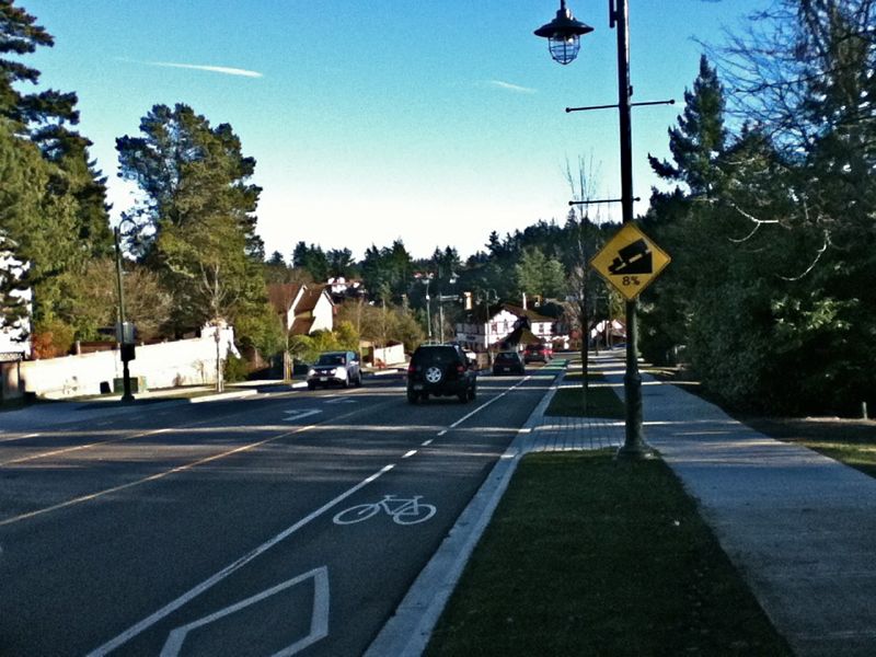

What does that say? 8% grade? Glad I'm not going up hill.

The rock wall put in across from the Four Mile Pub on this grade is exceptional though. It's not often you see such care taken to beautify what is otherwise a dull section of road. Hats off to the artists who spent last summer putting this rock wall in, and hats off to the township for planning it.

One of the nicest rock walls in the entire region.

After getting home I put the whole thing into a map that largely echoes what is already known. See the Map PDF document on the CRD website mentioned above. It looks nice in a map though. I'm looking forward to this trail being completed. It will be a fantastic commuter route when its done.


View Commuting in Victoria in a larger map


For now though, if you're commuting from Colwood or Langford, not a lot has changed. It's still bumper to bumper traffic at rush hour when the base lets out and cycling the route still leaves you jostling with cars along the Old Island Highway -- now with separate lanes for the most part.

Saturday, October 22, 2011

Tomatoes

The tomatoes I planted from seed back in March, flowered in June, and started producing tiny green tomatoes in early July. Over the rest of the summer more appeared and they grew larger. Unfortunately, they never turned red until September. They never did ripen on the vine. So we picked them and put them in a brown paper bag with a banana. That did the trick.

Tomatoes and small bell pepper from the patio garden.

Our garden was in planter pots on the deck -- well out of reach of the deer. Unfortunately, the garden only receives about four hours of sunlight a day before it turns to shade. Not ideal growing conditions for the pepper plants, or tomatoes. We ended up with two small green peppers though and a huge crop of green tomatoes.


Fresh salsa using our tomatoes.

So what do you do with tomatoes? Make salsa, of course. Aside from the chopping it is easy to make. The basic ingredients are lots of tomatoes, peppers (hot or mild), onion, cilantro, lime juice, oregano, salt and pepper. Very simple and very good. We've already made one batch and I'll be making another tonight.


Sunday, July 24, 2011

Mountains of Victoria, Part 2: Anderson Hill Park

Main entrance to Anderson Hill Park

Anderson Hill Park, in Oak Bay, is another place I didn't know about. It features a wide open hill with views of McNeill Bay and the Trial Islands.  I found my way in from Transit Road though there is a main entrance on Island road. As far as I can tell you can only park on Transit Road or Beach Drive.


Panorama from the top 


It is a short hike through sometimes overgrown trails along backyard fences. There are good views from the lookout along the way. The real payoff is at the top though. Plenty of benches to sit down on and enjoy the views of the Trial Islands and beyond. There are also views east to Discovery Island but the benches don't face that way.


View Anderson Hill Park in a larger map

Friday, May 13, 2011

Mountains of Victoria, Part1: Moss Rock Park

Ok, so I learned something new about Victoria. We were walking along Dallas Road on May 1, a surprisingly warm day amongst the cold ones we've been having, and I noticed this bump through the rooftops. I didn't know there was a small mountain in amongst the houses in Fairfield. Apparently, there is. Though, we didn't investigate further.

What is that bump, seen from Dallas Road?

Once home, I found Moss Rock Park on Google maps where it looks pretty flat:


The following weekend, May 7, another reasonable day with hints of sun, I set out to discover this hill for myself. Turning off of Fairfield road onto Masters road leads to the dirt track beside the hill seen in the second picture below. However, there is no parking, so turn around and park find your way to May Street. There is no official steps or trail into the park from May Street, but there are a few beaten paths through the bushes and up the rocks.

Moss Rock Park -- looking south, over Fairfield towards Clover Point.

It's a bit of a scramble up the rock, but the views are great.

Moss Rock Park -- Looking northwest towards downtown Victoria.

Every neighbourhood needs a small mountain viewpoint in the middle, and this is Fairfield's hill.

Moss Rock Park -- looking east towards Gonzales Hill and the Trial Islands.

Saturday, April 9, 2011

Optical phenomena

Look to the skies! A second sun has appeared overhead. Or is it just some optical effect? According to Wikipedia it is a Halo, so, nothing to get worried about. You can almost see the ring around the sun. Another reflection is off to the right, outside the cameras view. These halo's are due to ice crystals in the atmosphere. It wasn't a summer day, but it wasn't really cold down here.


There was also a rainbow halo around the sun and a reflection above that. Apparently, this is called a Circumzenithal Arc and appears due to refraction of light through ice crystals.


Very strange. Not something you see every day. Well worth a picture -- and a blog post -- on a very inactive blog.

Wednesday, February 23, 2011

Snow In Esquimalt

I had no idea this was coming. As soon as the radio said snow I was up and peering out the window, like a child again. It was quite a bit too, about 24cm. I took a walk over to Saxe Point and Macauley Point Parks hoping to take a few photos.

The Cairn Park

The Cairn Park appears deserted. People are still digging through garages looking for their magic carpets. The Cairn is too rocky to slide on anyway.

Fisgard Lighthouse

Saxe Point was deserted too. Fisgard Lighthouse (the first lighthouse in Western Canada) can be seen off in the distance from Saxe Point park.


Macaulay Point used to be a military defence position and is now a park. The bunkers and gun emplacements are still there.


It was starting to snow harder so I left for home. My camera was getting damp. I spotted this sign on the way home. I'm not sure it was really necessary.

Monday, February 7, 2011

Fleming Beach Climbing Wall

There's nobody on the Fleming Beach climbing wall on a rainy Sunday afternoon in February ( map ). It's a different scene in the middle of summer. According to the Climbers Access Society there is a $10 fee for an annual pass in order to be able to climb here. Any climber looking at the following photo will notice the chalk marks and immediately plan their route to the top. I wonder if anyone has made a climbing video at Fleming Beach. I suspect not -- there's no 5.13 routes here.


Additional hazards to climbing outdoors here appear to be the small presents left by dogs whose owners do not pick up after them. The bicycle in the photo is not a hazard. It has been removed by its owner.